In a study that gives new meaning to the term “rock bottom,” seismic researchers have discovered the underside of a rocky slab of Earth’s surface layer, or lithosphere, that has been pulled more than 400 miles beneath northeastern China by the process of tectonic subduction.
The study, published by a team of Chinese and U.S. researchers in Nature Geoscience, offers news evidence about what happens to water-rich oceanic tectonic plates as they are drawn through Earth’s mantle beneath continents.
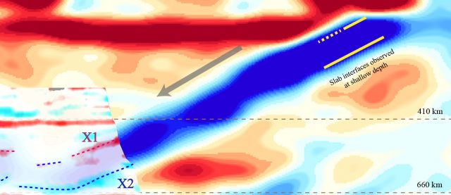
Rice University seismologist Fenglin Niu, a co-corresponding author, said the study provides the first high-resolution seismic images of the top and bottom boundaries of a rocky, or lithospheric, tectonic plate within a key region known as the mantle transition zone, which starts about 254 miles (410 kilometers) below Earth’s surface and extends to about 410 miles (660 kilometers).
“A lot of studies suggest that the slab actually deforms a lot in the mantle transition zone, that it becomes soft, so it’s easily deformed,” Niu said. How much the slab deforms or retains its shape is important for explaining whether and how it mixes with the mantle and what kind of cooling effect it has.
Earth’s mantle convects like heat in an oven. Heat from Earth’s core rises through the mantle at the center of oceans, where tectonic plates form. From there, heat flows through the mantle, cooling as it moves toward continents, where it drops back toward the core to collect more heat, rise and complete the convective circle.
Find your dream job in the space industry. Check our Space Job Board »
Previous studies have probed the boundaries of subducting slabs in the mantle, but few have looked deeper than 125 miles (200 kilometers) and none with the resolution of the current study, which used more than 67,000 measurements collected from 313 regional seismic stations in northeastern China. That work, which was done in collaboration with the China Earthquake Administration, was led by co-corresponding author Qi-Fu Chen from the Chinese Academy of Sciences.
The research probes fundamental questions about the processes that shaped Earth’s surface over billions of years. Mantle convection drives the movements of Earth’s tectonic plates, rigid interlocked pieces of Earth’s surface that are in constant motion as they float atop the asthenosphere, the topmost mantle layer and the most fluid part of the inner planet.
Where tectonic plates meet, they jostle and grind together, releasing seismic energy. In extreme cases, this can cause destructive earthquakes and tsunamis, but most seismic motion is too faint for humans to feel without instruments. Using seismometers, scientists can measure the magnitude and location of seismic disturbances. And because seismic waves speed up in some kinds of rock and slow in others, scientists can use them to create images of Earth’s interior, in much the same way a doctor might use ultrasound to image what’s inside a patient.
Niu, a professor of Earth, environmental and planetary sciences at Rice, has been at the forefront of seismic imaging for more than two decades. When he did his Ph.D. training in Japan more than 20 years ago, researchers were using dense networks of seismic stations to gather some of the first detailed images of the submerged slab boundaries of the Pacific plate, the same plate that was imaged in study published this week.
“Japan is located about where the Pacific plate reaches around 100-kilometer depths,” Niu said. “There is a lot of water in this slab, and it produces a lot of partial melt. That produces arc volcanoes that helped create Japan. But, we are still debating whether this water is totally released in that depth. There is increasing evidence that a portion of the water stays inside the plate to go much, much deeper.”
Northeastern China offers one of the best vantage points to investigate whether this is true. The region is about 1,000 kilometers from the Japan trench where the Pacific plate begins its plunge back into the planet’s interior. In 2009, with funding from the National Science Foundation and others, Niu and scientists from the University of Texas at Austin, the China Earthquake Administration, the Earthquake Research Institute of Tokyo University and the Research Center for Prediction of Earthquakes and Volcanic Eruptions at Japan’s Tohoku University began installing broadband seismometers in the region.
“We put 140 stations there, and of course the more stations the better for resolution,” Niu said. “The Chinese Academy of Sciences put additional stations so they can get a finer, more detailed image.”
In the new study, data from the stations revealed both the upper and lower boundaries of the Pacific plate, dipping down at a 25-degree angle within the mantle transition zone. The placement within this zone is important for the study of mantle convection because the transition zone lies below the asthenosphere, at depths where increased pressure causes specific mantle minerals to undergo dramatic phase changes. These phases of the minerals behave very differently in seismic profiles, just as liquid water and solid ice behave very different even though they are made of identical molecules. Because phase changes in the mantle transition zone happen at specific pressures and temperatures, geoscientists can use them like a thermometer to measure the temperature in the mantle.
Niu said the fact that both the top and bottom of the slab are visible is evidence that the slab hasn’t completely mixed with the surrounding mantle. He said heat signatures of partially melted portions of the mantle beneath the slab also provide indirect evidence that the slab transported some of its water into the transition zone.
“The problem is explaining how these hot materials can be dropped into the deeper part of the mantle,” Niu said. “It’s still a question. Because they are hot, they are buoyant.”
That buoyancy should act like a life preserver, pushing upward on the underside of the sinking slab. Niu said the answer to this question could be that holes have appeared in the deforming slab, allowing the hot melt to rise while the slab sinks.
“If you have a hole, the melt will come out,” he said. “That’s why we think the slab can go deeper.”
Holes could also explain the appearance of volcanos like the Changbaishan on the border between China and North Korea.
“It’s 1,000 kilometers away from the plate boundary,” Niu said. “We don’t really understand the mechanism of this kind of volcano. But melt rising from holes in the slab could be a possible explanation.”
More information: Xin Wang et al. Distinct slab interfaces imaged within the mantle transition zone. Nature Geoscience (2020). DOI: 10.1038/s41561-020-00653-5
Image: Seismic imaging in northeastern China revealed both the top (X1) and bottom (X2) boundaries of a tectonic plate (blue) that formerly sat at bottom of the Pacific Ocean and is being pulled into Earth’s mantle transition zone, which lies about 254-410 miles (410-660 kilometers) beneath Earth’s surface.
Credit: F. Niu/Rice University


