


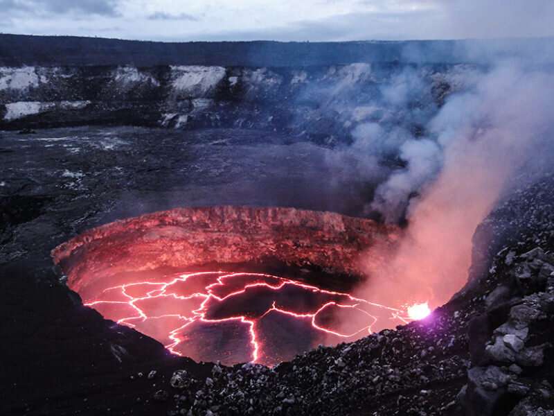
Two new studies investigate activity at Hawaii’s Kīlauea leading up to and following the 2018 eruption to better understand the volcano’s plumbing and behavior.
Kīlauea in Hawaii is the best-monitored volcano in the world. The 2018 eruption was the largest in some 200 years, providing researchers with a plethora of new data to understand the volcano’s plumbing and behavior. Two new studies dig into data on volcanic tremor and deformation to better characterize the events leading up to and following the 2018 eruption.
In one study, Soubestre et al. used data from a permanent seismic network and tiltmeter located at Kīlauea’s summit and derived models of tremor source processes to examine how volcanic tremors related to the disappearance of a lava lake and subsidence in Halema’uma’u Crater at the beginning and throughout the 2018 eruption. Here the authors used a seismic network covariance matrix approach to enhance coherent signals and cut out noise to detect and locate the volcanic tremor sources.
The team identified three previously unidentified tremor sources, including long-period tremor during the period preceding the eruption associated with radiation from a shallow hydrothermal system on the southwest flank of Halema’uma’u Crater. The team picked up on two sets of gliding tremor in early and late May. Models show that the first set was linked to the intrusion of a rock piston into the hydrothermal system and the second was linked to changes in the gas content of magma within a dike below the crater affected by a dozen collapse events.
The second study focused on the period following the 2018 eruption. Here Wang et al. used GPS and interferometric synthetic aperture radar data to examine deformation around the caldera associated with the volcano’s known reservoirs—the shallow Halema’uma’u reservoir (HMM) and the deeper South Caldera reservoir (SC)—after the eruption ended in August of 2018. They documented inflation on the northwestern side of the caldera and deflation on the southeastern side of the caldera, indicating that the summit magma chambers are hydraulically distinct. The concurrent East Rift Zone (ERZ) inflation indicated dynamic magma transfer between the summit and the ERZ.
Find your dream job in the space industry. Check our Space Job Board »
The authors presented a new physics-based model that uses differential equations to describe reservoir pressure and magma flux between the volcano’s reservoirs to simulate potential magmatic pathways of connectivity between the reservoirs and the ERZ. They used a dynamic inversion of the postcollapse GPS time series of surface displacement to estimate the conductivity of potential magmatic pathways.
The team found that the primary connective pathway in the postcollapse period that best fits the GPS data is a shallow connection between the HMM and the ERZ. The study doesn’t rule out a direct pathway between the SC and ERZ reservoirs but suggests that if it exists, it was significantly less active over the study period.


